Skip to product information
1 of 8

DJI MATRICE 400 - PRICE ON REQUEST

DJI MATRICE 400 - PRICE ON REQUEST

Regular price R 0.00
Regular price Sale price R 0.00
Sale Sold out
Taxes included.

DJI M400

Long-Endurance Drone Platform With Power-Line-Level Obstacle Sensing

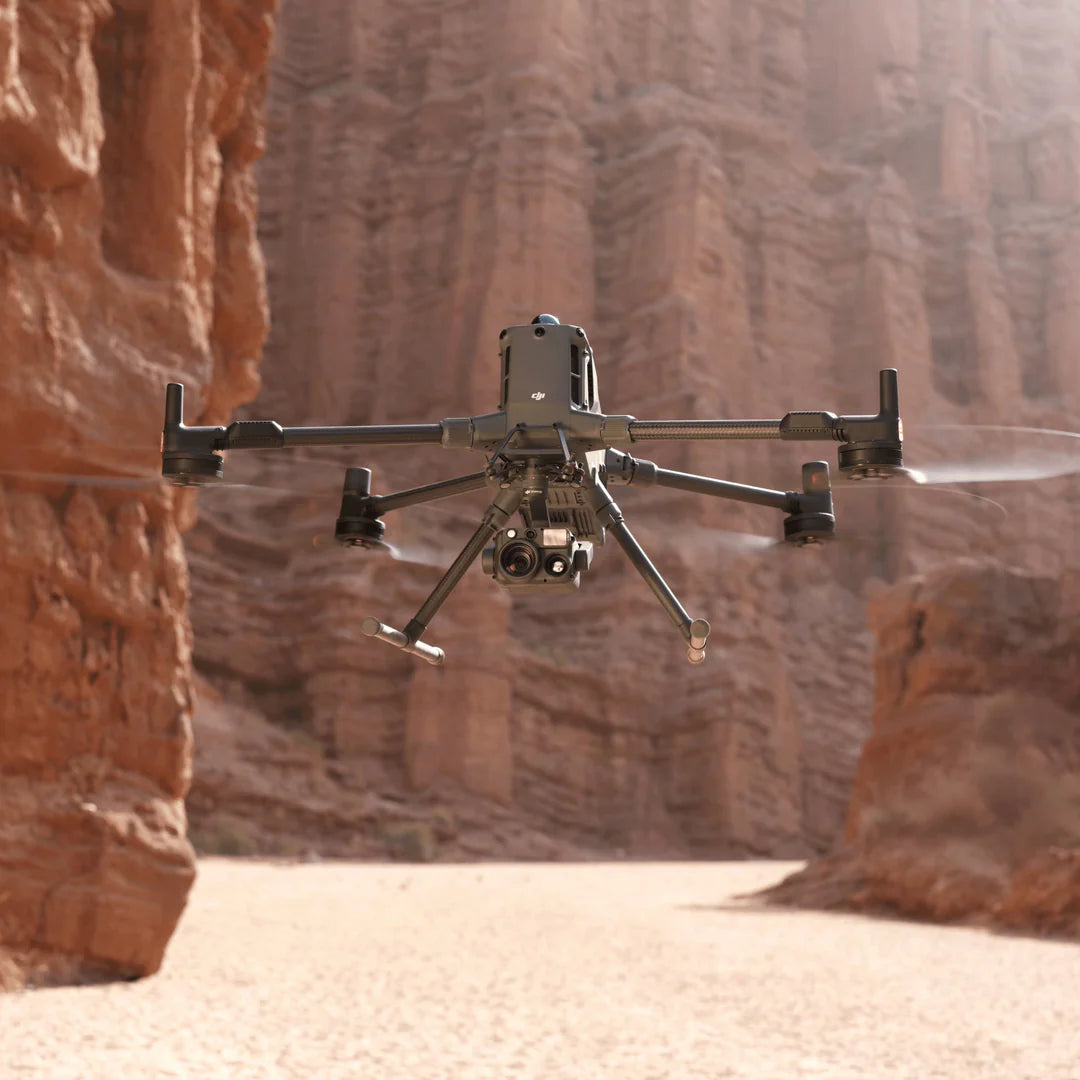
The DJI Matrice 400 stands as the flagship of DJI’s enterprise drone lineup, offering outstanding performance with up to 59 minutes of flight time and a maximum payload capacity of 6 kg. Designed for demanding environments, it integrates rotating LiDAR and mmWave radar for high-precision obstacle detection—particularly valuable around infrastructure like power lines. With O4 Enterprise Enhanced Video Transmission and Airborne Relay Video Transmission, the M400 delivers enhanced connectivity and operational safety.

Engineered for versatility, the Matrice 400 features intelligent detection systems, dual visible and thermal imaging, AR projection, ship-based takeoff and landing, and advanced automation. These capabilities make it a reliable asset for emergency response, power line inspection, mapping, and AEC (architecture, engineering, and construction) missions.

The M400 is compatible with a wide range of payloads, allowing it to adapt seamlessly to various industry needs. Pair it with the DJI Zenmuse L2 or P1 for high-accuracy surveying and mapping, or with the Zenmuse H30T for robust visual and thermal imaging—ideal for inspections, security, and surveillance. Public safety teams can also equip it with the Zenmuse V1 Spotlight and S1 Speaker to ensure effective communication and visibility during urgent operations.

Extended Flight Time, High Speed Performance

The Matrice 400 delivers exceptional flight performance, with up to 59 minutes of forward flight time—even while carrying a payload—and up to 53 minutes of hover time. These impressive endurance capabilities make it ideal for extended missions such as search and rescue, firefighting, and large-scale mapping. Designed for demanding environments, the M400 can detect and avoid large obstacles like buildings and mountains while flying at speeds of up to 25 m/s, ensuring safe and efficient operations in complex terrains.

Multi-Payload, Multi-Scene

The Matrice 400’s robust payload capacity—up to 6 kg—makes it highly adaptable for a wide range of mission requirements. It supports quick transitions between a single or dual downward gimbal setup and includes a third gimbal connector on the underside for added versatility. Additionally, with four external E-Port V2 interfaces, the M400 can carry and operate up to seven payloads simultaneously, offering unmatched flexibility for complex, multi-sensor operations.


Safe and Reliable Flight

Built for Challenging Conditions

The Matrice 400 is built for tough environments, featuring an IP55 protection rating that enables reliable operation in harsh conditions such as heavy rain or dust. Engineered for resilience, it performs consistently in extreme temperatures ranging from -20°C to 50°C (-4°F to 122°F), ensuring dependable results in both hot and cold climates


Power-Line-Level Obstacle Sensing

The Matrice 400 features an advanced obstacle sensing system that combines rotating LiDAR, high-precision mmWave radar, and full-color low-light fisheye vision sensors, delivering exceptional situational awareness. This powerful system can detect even small obstacles—such as high-voltage power lines—across rugged, mountainous terrain, and maintains accuracy even in low-light or nighttime conditions. Capable of sensing through rain and fog, it ensures enhanced operational safety in challenging weather and complex environments.


Power-Line-Level Obstacle Sensing

The Matrice 400 is equipped with a cutting-edge obstacle sensing system that fuses rotating LiDAR, high-precision mmWave radar, and full-color low-light fisheye vision sensors, elevating detection capabilities to new heights. It can identify even the smallest obstacles—such as high-voltage power lines—across mountainous terrain, including during nighttime operations. The system also penetrates rain and fog, ensuring reliable environmental awareness and enhanced flight safety in adverse weather conditions.


Robust Video Transmission

O4 Enterprise Enhanced Video Transmission System

Thanks to the ten-antenna system on the aircraft and the high-gain phased array antenna system on the remote controller, the O4 Enterprise Enhanced Video Transmission System can achieve image transmission up to 40 km [10].

Matrice 400 also supports the sub2G frequency band [5], and when equipped with two DJI Cellular Dongle 2 [11], it can automatically switch to the better available carrier network, providing a more stable signal even in urban interference environments or remote regions.


Airborne Relay Video Transmission

Matrice 400 has a built-in video transmission relay module. With this setup, one Matrice 400 can serve as a relay drone, flying high to provide relay signals for another Matrice 400 operating at a greater distance. This capability significantly extends the transmission range, making it ideal for search and rescue tasks as well as inspections in mountainous areas.


Aircraft Fusion Positioning

The Matrice 400’s omnidirectional sensing system—powered by rotating LiDAR, high-precision mmWave radar, and full-color low-light fisheye vision sensors—delivers exceptional positioning accuracy. This allows the drone to fly steadily near complex structures like glass-facade buildings or wind turbine blades, and safely navigate back from challenging locations such as mountain bases, bridge edges, or building sides—even when the return point hasn’t been refreshed.


Full-Color Vision Assist

The Matrice 400 is equipped with four full-color, low-light fisheye vision sensors that enable Full-Color Vision Assist, enhancing situational awareness and ensuring safer flight, even in low-light environments.


Intelligent Flight Modes
Cruise

Activate cruise control mode to pilot the drone in a specific direction without constantly pressing the control sticks, making long-distance flights or linear inspections easier.

FlyTo

In emergencies or disasters, the drone can automatically adjust its flight path and speed based on the surrounding environment, allowing it to reach a designated location without manual adjustments.

Smart Track

Smart Track allows for precise subject positioning and automatic zoom adjustments, allowing you to switch between subjects easily. It can automatically reacquire a subject even if obscured briefly.

POI

POI enables continuous observation and 3D modeling of buildings while orbiting a designated area, greatly enhancing the efficiency of fixed-point observation and modeling tasks.

Enhanced Intelligence and Efficiency

Smart Detection

Equipped with the Zenmuse H30 Series’ visible and thermal imaging, the Matrice 400 can effectively detect vehicles, vessels, and individuals during search and rescue missions or routine patrols. Its flexible payload compatibility allows for easy switching to other camera models, broadening its range of applications. The system also supports high-resolution grid photography and offers advanced subject tracking for enhanced mission efficiency.


Smart AR Projection

Power Line AR

During tasks such as power grid inspection, the obstacle sensing system automatically detects frontal wire obstacles and displays easily recognizable AR lines on the remote controller’s screen, making the surrounding environment clear at a glance and ensuring safer flight.

Map View AR

When operating during the day or night in urban regions, the remote controller can display the names of buildings and landmarks in real-time, marking core roads with prominent lines.

AR Flight Waypoint

Real-time route preview is available for the drone during RTH, obstacle sensing, and FlyTo operations. During landing, the AR Aircraft Shadow can be displayed to help operators confirm the landing location.

Live Annotations

Without modeling, you can mark points on the remote controller screen to obtain subject locations, draw lines to measure distances between multiple points, and outline areas to calculate their size. Measurement results can be synchronized to the DJI FlightHub 2 to enhance team efficiency.


Real-Time Terrain Follow

The Matrice 400 supports Real-Time Terrain Follow in all horizontal directions, maintaining a stable altitude relative to the ground during both manual and automated flight paths.

In large-scale search and rescue missions, this feature ensures that ground subjects appear at a consistent size on the remote controller screen, minimizing the need for constant zoom adjustments and enhancing operational efficiency. For mapping tasks, it helps maintain a uniform ground sampling distance (GSD), enabling the collection of high-precision mapping data.


Takeoff and Landing on Ships

Designed to meet the demands of offshore missions like maritime patrol and wind turbine inspections, the Matrice 400 is capable of taking off from stationary vessels and landing on moving ones. It uses deck pattern recognition to identify landing zones, enabling safe and accurate landings even in dynamic marine environments.


Enhanced Easier Automated Operations and Efficiency

Power Line Follow With Zenmuse L2

When equipped with the L2 LiDAR system, Matrice 400 can perform automated power transmission and distribution line following flights. It uses the rotating LiDAR to detect obstacles in real time and automatically bypasses crossing lines.

Slope Route & Geometric Route

Matrice 400 supports the planning and execution of slope and geometric routes via DJI Pilot 2 or DJI FlightHub 2. Whether conducting detailed aerial surveys of building facades, slopes, or other inclined surfaces, or collecting mapping data of individual buildings or structures, Matrice 400 can quickly plan slope or geometric routes to efficiently acquire high-precision data.


View full details